Free viewpoints on the Canadian side of Niagara Falls
Where can you see Niagara Falls for free on the Canadian side?
Table Rock Welcome Centre sits right at the crest of the Horseshoe Falls and costs nothing to visit. Queen Victoria Park and the Niagara Parkway add more free viewpoints to the north and south, and the Niagara Glen offers a free, physically demanding trail through the gorge below the falls.
A full day of views without spending a dollar on entry
The Canadian side of Niagara Falls has more free viewpoints than most visitors realize, because the paid attractions — Journey Behind the Falls, the Niagara Parks Power Station tunnel, the Skylon’s observation deck — sit right next to public ground that costs nothing to stand on. You can spend a full day working your way along the Niagara Parkway and see the Horseshoe Falls from four or five distinct angles without buying a single ticket. What you will pay for, almost everywhere, is parking.
This guide covers the free stretch from Table Rock north through Queen Victoria Park, the open ground around the base of the Skylon Tower, the belvederes along the Parkway up to Dufferin Islands, and the Niagara Glen further along the river. It does not cover Terrapin Point on the American side or the interior of Table Rock itself, both of which have their own dedicated pages — this one stays on the Canadian bank.
Table Rock: the closest free view there is
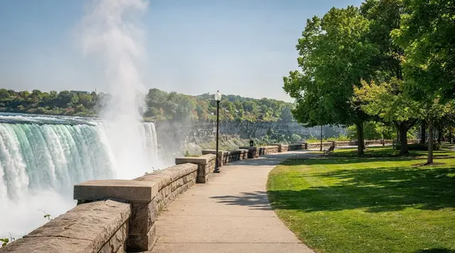
Table Rock Welcome Centre sits directly on the crest of the Horseshoe Falls, and the outdoor railing along the water is open to anyone, at any hour, at no cost. This is the single closest vantage point to the falls on either side of the border — close enough that the mist reaches you on a normal day and soaks you outright when the wind shifts. The building itself houses ticketed attractions, but the viewing area and the plaza in front of it are public.
Because it’s the closest and easiest viewpoint to reach, Table Rock is also the busiest spot on this list. Expect a wall of people at the railing on summer afternoons and at illumination time in the evening. For the fuller story on Table Rock’s layout, and how it compares to the American side’s Terrapin Point and Luna Island, see the dedicated Table Rock guide — this page treats it only as the first stop on a longer walk.
Queen Victoria Park: the wide-angle version
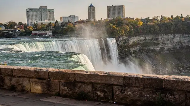
Walk north from Table Rock along the river and you’re in Queen Victoria Park within a few minutes. This is where the view opens up: the path runs along the top of the gorge with an unbroken sightline across the Horseshoe Falls and, further along, the American Falls and Bridal Veil Falls on the far bank. It’s less crowded than the railing at Table Rock simply because there’s more path to spread out along, and it’s the better spot for a photo that takes in more than one waterfall at once.
The park itself, maintained by the Niagara Parks horticultural staff, is landscaped with seasonal flower beds and mature trees, and it’s a pleasant walk even setting the falls aside. In spring and summer the plantings are worth slowing down for. The path connects directly to the Niagara Falls, Ontario tourist core, so it’s an easy add-on whether you’re arriving from Fallsview above or Clifton Hill’s neighbourhood below — though Clifton Hill’s attractions themselves have nothing to do with viewing the falls, and are worth reading about separately if you’re weighing whether they’re worth your time at all.
If you’d rather cover this stretch with a guide filling in the history and geology as you go, a walking tour that keeps you on foot through the mist zone does the same ground with narration — a guided walk through the spray along this exact stretch of riverbank covers Table Rock and Queen Victoria Park together in a couple of hours.
The Skylon’s free ground floor
The Skylon Tower, opened in 1965, charges for its observation deck and revolving restaurant 160 metres up — but the plaza and gardens at its base are open ground, free to walk through, and sit at a slightly elevated position relative to the river that gives a genuinely different angle on both the Horseshoe and American Falls than you get down at water level. It won’t match the tower’s bird’s-eye view, but it costs nothing and takes five minutes to reach from the Fallsview hotel strip.
For visitors trying to decide whether the paid deck is worth adding to the day, the comparison between the Skylon and the American side’s Prospect Point Observation Tower lays out what each one actually adds over the free ground-level views — useful reading before you commit to the ticket.
North along the Parkway to Dufferin Islands
The Niagara Parkway runs about 55 kilometres from Fort Erie to Niagara-on-the-Lake, and the stretch immediately north of the falls is dotted with small pull-offs and belvederes that most day-trippers drive past without stopping. None of them beat Table Rock or Queen Victoria Park for a head-on view of the Horseshoe, but they’re worth the short detour for a quieter, more natural stretch of riverbank once you’re past the tourist core — the floral clock, the Floral Showhouse gardens, and Dufferin Islands itself, a network of small footbridges over quiet ponds that’s a deliberate change of pace from the crowds at the crest.
This same stretch is where the Winter Festival of Lights sets up its display each year from November to January, free to drive or walk through after dark — one of the few times of year the Parkway itself is worth visiting specifically after sunset, rather than just as a route between viewpoints.
The Niagara Glen: free, but you earn it
The Niagara Glen Nature Reserve is the outlier on this list, and it’s worth treating separately because it isn’t really a “viewpoint” in the same sense as the others — it’s a trail, and a demanding one. Admission is free, and it covers roughly 4 kilometres of trail through Carolinian forest scattered with glacial erratics along the gorge, but reaching the river requires descending about 60 metres on a steep metal staircase. The falls themselves aren’t visible from the Glen; what you get instead is the gorge and the river at close range, in a setting that feels nothing like the manicured parkland further south.
The physical demand is the honest caveat here: the descent is straightforward, but the climb back up the same staircase is not a stroll, and there’s no shortcut or elevator. Anyone with knee or mobility concerns should treat this stop as optional rather than essential. For a full breakdown of the trail network and what to expect underfoot, see the guide to gorge trails on the Canadian side.
What you are actually looking at
The Horseshoe Falls drops 57 metres across a crest about 670 metres wide, and every free viewpoint on this page shows it from a different distance. Table Rock puts you at the lip, where the water’s speed is the whole story. Queen Victoria Park pulls back far enough to read the shape of the horseshoe. The Skylon plaza adds height. Seeing the three in sequence is worth more than lingering at any single railing, because the falls change character with distance in a way a photo never quite captures.
The volume you see also changes with the calendar. Under the 1950 treaty, at least 2,832 cubic metres per second must pass over the falls during daytime hours from 1 April to 31 October, and 1,416 cubic metres per second the rest of the year, with the remainder going to the power plants. In practice, a winter visit shows a thinner curtain of water, often framed by ice and heavy spray, while a summer visit gives you the full roar. Neither is the “wrong” time for a free day out, but they suit different moods, and the month-by-month weather guide helps you pick.
Free views through the seasons
Summer brings the longest days, the busiest railings and the best chance of a dry morning at Table Rock. Arrive early and the plaza is calm; by early afternoon the crowd at the crest is several people deep. Autumn is quieter and the park’s trees add colour behind the falls, which makes Queen Victoria Park the better choice for photographs. Winter is the season when free views matter most, since many paid attractions scale back, while the railings, the illumination and the park paths stay open. Check what is open and closed by season before you plan around any indoor stop, and dress for wind off the water, because the spray freezes on railings and paths in cold weather.
Bring a light waterproof layer in every season. The mist at Table Rock is not a drizzle you can ignore, and anything you carry that cannot get wet, a phone or a camera especially, should stay in a sealed bag until you are back from the railing.
Free and paid, side by side
None of this means the paid options are a bad idea. Free viewpoints show you the falls; the tickets put you on the water, behind the curtain or in the air. If you have a budget for one extra, a guided small-group day that combines the tower, a boat and Journey Behind the Falls is the efficient way to add all three without queuing separately — a small-group tour that strings the tower, the journey behind the falls and the boat together is the version built for people with limited time. Otherwise, the free railing and a good pair of walking shoes already give you the core of the experience.
Parking: the real cost of a “free” day
None of the viewpoints above charge admission, but almost none of them offer genuinely free parking either. Every Niagara Parks lot along this stretch charges by the hour, rates climb through the summer season, and the closest lots to Table Rock fill by mid-morning on weekends and holidays. Budgeting for parking, or avoiding it altogether, is the one line item that turns a “free” day into one with a real cost attached.
| Stop | Nearest paid lot | Typical fill time (summer weekend) | Free alternative |
|---|---|---|---|
| Table Rock | Table Rock lot | Mid-morning | WEGO bus, or walk from Fallsview hotels |
| Queen Victoria Park | Falls Avenue / Murray Street lots | Late morning | Walk from Table Rock (10–15 minutes) |
| Skylon base | Skylon lot or Fallsview lots | Late morning | Walk from Table Rock or Clifton Hill area |
| Dufferin Islands / Parkway | Small pull-offs, limited spots | Early afternoon | Cycle the Parkway path instead |
| Niagara Glen | Glen lot, small capacity | Midday | Arrive before 10 a.m. |
The most reliable workaround is the WEGO bus network, which links Fallsview, Clifton Hill, and the Parkway corridor without needing a parking spot at all — see the guide to getting around with WEGO and the Falls Incline Railway for routes and fares. If you’re driving in from Toronto for the day, the Toronto to Niagara Falls guide covers timing around the QEW that affects how early you need to leave to beat the lots filling up.
Putting it together: a free-viewpoints route
A sensible order, on foot, starts at Table Rock and works outward in both directions rather than backtracking:
- Table Rock — arrive early, before the crowd builds.
- Queen Victoria Park — walk north along the river path.
- Skylon base — a short walk further, worth the detour even without the ticket up top.
- Dufferin Islands or the Parkway belvederes — better suited to a bike or a car than a long walk from Table Rock.
- Niagara Glen — a separate stop, best treated as its own outing given the staircase.
Steps one through three fit comfortably into a morning. Adding Dufferin Islands and the Niagara Glen turns it into a full day, and the one-day Niagara Falls itinerary works through a version of this same route alongside the paid attractions worth adding if your budget has room. For visitors weighing free viewpoints against a broader look at where money is actually well spent, the full-day free things to do guide and the day-trip budget breakdown for two people both build on this same ground.
If a full paid day still appeals — helicopter, boat, and tower combined — a helicopter flight over the falls paired with a boat ride and a buffet meal is the splurge version of the same views covered here for free, and a combined day covering the boat tour, the Skylon deck, and Journey Behind the Falls bundles the paid attractions that sit right beside every free stop on this list.
For something more active than standing at a railing, a zip line ride down toward the base of the Horseshoe Falls starts near the same stretch of riverbank.
Photographing the free viewpoints
Each of these spots photographs differently depending on the hour. Table Rock’s proximity means the mist frequently interferes with a clean shot, especially with any wind out of the northwest; Queen Victoria Park’s greater distance from the crest actually produces sharper images more of the time.
The guide to the best times to photograph the falls and the companion piece on what the mist does to your camera are both worth reading before you plan a dedicated photo stop, particularly if the illumination or fireworks are the goal — see photographing the illumination and fireworks for the specifics of shooting after dark from any of these free spots.
Whichever side you’re comparing against
Visitors splitting time between both banks of the river often ask which side actually has the better free views, and the honest answer depends on what you’re after: the Canadian viewpoints covered here face the Horseshoe Falls head-on, while the American side gets you physically closer to the water via the gorge trails and Goat Island. The Canada versus USA side comparison walks through that trade-off in more detail, and the American side’s free viewpoints guide is the direct counterpart to this page if you’re planning to cross the border for part of the day.
Viewpoints, towers and observation decks on GetYourGuide
Verified deep-linked GetYourGuide tours. Book through these links and we earn a small commission at no cost to you.
GetYourGuide does not provide a product photo for this activity — the image shows the meeting point, photographed by us.