The gorge behind the postcard
Everyone who visits Niagara Falls sees the crest of the falls and the mist. Almost nobody walks into the gorge the water carved to get there. The Niagara Gorge runs about 11 km from the base of the falls north to Lake Ontario, and its walls are the physical record of 12,500 years of erosion: the falls themselves have retreated the entire length of that gorge, cutting backward through the rock at roughly 1 to 1.5 metres a year before twentieth-century hydroelectric diversions slowed the flow over the crest, and at closer to 30 cm a year today. Stand at the bottom of a gorge staircase and you’re standing where the falls themselves stood thousands of years ago.
Most visitors experience the gorge from above — a paved path, a railing, a photo. The Niagara Gorge Trail is the other option: a free, unimproved route that actually descends into it. This page covers that hike specifically, on the American side. If you want the Whirlpool itself, or the quieter trail past Devil’s Hole, those get their own dedicated pages further down this guide, since each is a separate outing with its own trailhead and its own feel.
Not the White Water Walk — a genuinely different thing
The most common mix-up is confusing this trail with the White Water Walk on the Canadian side. That’s fair, since both put you at river level next to the same rapids. But they’re built for opposite purposes.
The White Water Walk is a paid Niagara Parks attraction: you pay admission, ride an elevator 70 metres down, and walk a boardwalk with railings alongside class VI rapids. It’s comfortable, accessible to most fitness levels, and designed to be visited in twenty or thirty minutes on the way to somewhere else.
The Niagara Gorge Trail has none of that. There’s no elevator, no boardwalk, no ticket window, and in most stretches no railing. You descend a stone staircase built into the gorge wall, and what waits at the bottom is loose rock and packed dirt, not a paved surface. It’s free precisely because nobody has built or staffed anything — you’re walking a natural gorge, not a managed attraction. Treat it as a real hike, not a fifteen-minute detour, and it delivers something the paid attractions can’t: real solitude next to the same river.
Where it starts and how the pieces connect
The gorge trail system isn’t one continuous, marked path from end to end so much as a series of connected trail segments with their own access points. On the American side, the pieces you’ll actually use are:
- Within Niagara Falls State Park — the southernmost access, close to Goat Island and the Robert Moses Parkway multi-use path, which runs along the gorge rim and links the park to the trailheads further north.
- Whirlpool State Park — roughly 4.8 km (3 miles) north, where a steep staircase drops to a rocky beach at the edge of the Whirlpool itself.
- Devil’s Hole State Park — further north again, a quieter, less-visited stretch of the same gorge with its own descent and its own parking lot.
Each of these functions as its own trailhead with its own lot, and the connecting rim path between them is flat and easy — it’s only the descents into the gorge itself that turn strenuous. A reasonable plan for a first visit is to pick one descent rather than trying to string all three together in a single afternoon; the elevation change adds up faster than the map distance suggests.
The terrain, honestly
This is the part that catches people out. The Niagara River gorge above the falls looks tame from a car window on the Robert Moses Parkway — trees, a rim trail, glimpses of rapids below. Once you commit to a descent, the character changes fast.
The main staircases drop roughly 90 to 100 metres in elevation over a few hundred metres of trail, on stone steps that are uneven, sometimes wet from spray or rain, and without railings for most of the descent. At the bottom, the gorge floor is talus — loose, fist-to-boulder-sized rock left over from centuries of rockfall off the gorge walls — not a groomed surface. Ankles turn on this kind of ground more easily than people expect, and the climb back out is the same staircase in reverse, now uphill, after your legs are already tired.
None of this is exotic by hiking-trail standards elsewhere, but it’s a real step up from the flat, paved circuits around the falls themselves, and it’s worth saying plainly: wear actual hiking or trail shoes, bring water, and budget more time than the map distance implies. This is not a trail for flip-flops, strollers, or anyone who needs level, railed ground — for that, the paths inside Niagara Falls State Park itself remain the better choice.
What you actually see down there
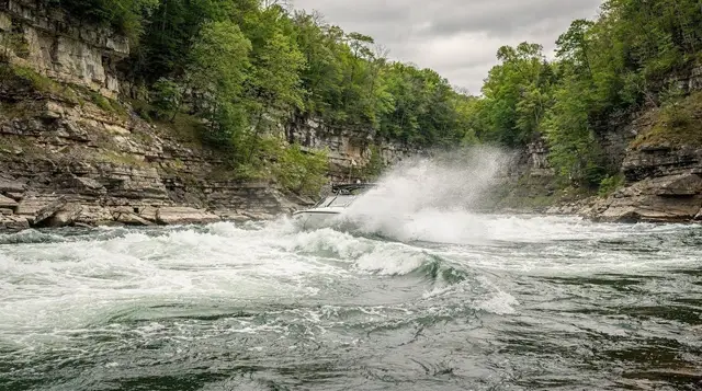
The payoff is a different vantage on the same river everyone else is watching from above. At river level you get close, loud views of the class V and VI rapids that most visitors only glimpse from the Whirlpool Aero Car or a bridge railing. The gorge walls themselves expose horizontal bands of sedimentary rock — the same layers the falls have been cutting through for 12,500 years — and reading them is a genuinely good way to understand why the falls have moved as far as they have, and why they keep moving.
Wildlife is part of it too: turkey vultures riding the thermals off the gorge walls, and in the quieter northern stretches near Devil’s Hole, a noticeably different soundscape from the crowds at the falls themselves — just the river.
If your appetite runs more to the geology and river-science side of this than the physical hike, the dedicated trail guide covers route options and current conditions in more depth, and it’s worth reading before you go: Niagara Gorge trail guide, American side. The Canadian gorge trail, Niagara Glen, is a separate hike with its own descent and its own reserve, covered here: Niagara Glen gorge trails, Canadian side.
Getting there and parking
The southern trailheads sit inside or beside Niagara Falls State Park, where paid parking lots are the norm and fill up on summer weekends — the practical details are in parking on the American side. Whirlpool State Park and Devil’s Hole State Park, further north along the Robert Moses Parkway, have their own smaller lots that are usually free or low-cost and rarely fill up.
There’s no shuttle service equivalent to the Canadian side’s WEGO along this stretch, so a car (or a taxi/rideshare between trailheads) is the practical way to link the segments. If you’re coming from Buffalo, the gorge trailheads are on the direct route in from the airport and closer than the falls themselves by a few kilometres. If you’re staying in Lewiston, the Devil’s Hole end of the trail system is the nearer access point.
Combining the hike with the rest of the falls
Because the trail is free, it pairs naturally with a paid attraction on the same day rather than replacing one. A common, sensible day on the American side: walk part of the gorge trail in the morning while it’s cooler and quieter, then spend the afternoon on the water itself. The boat trip that gets you closest to the base of the falls from the American dock is the Maid of the Mist boat and walking tour on the American side, and the version that adds the Cave of the Winds walkways is the combined Maid of the Mist and cave adventure ticket.
If the rapids you saw from the gorge floor made you want to be on the water rather than beside it, the jet boat trip that runs the same stretch of river is a reasonable next stop: the 45-minute jet boat tour on the Niagara River covers similar ground to the Whirlpool trail from the water side, and the route and seasonal details are laid out in Whirlpool jet boat tours.
For a look at the falls themselves from behind and above, rather than from the gorge, the Beyond the Falls walking tour and cruise covers the tunnels and viewing platforms on the Canadian side, which is the natural point of comparison for anyone weighing Canada versus the USA side of the falls.
None of this requires crossing into Canada to enjoy — the gorge trail, the boat tours, and Cave of the Winds are all reachable from the American side without touching Rainbow Bridge at all, which matters if you’re short on time or travelling without a passport that covers the crossing.
What to pack and how to pace yourself
There is no shop, no snack bar and no staff at the bottom of a gorge staircase, so everything you need goes in your bag before you start. Water matters most, followed by shoes with real grip: wet stone near the spray is slick, and talus punishes soft soles. A light layer helps too, because the gorge floor sits in shade and feels cooler than the rim, then turns humid once you start climbing back up.
Go down slowly and treat the climb out as the hard half of the outing. Stop on the staircase rather than on the narrow stretches, let faster hikers pass, and keep your eyes on your feet whenever you are moving. If you want to photograph the rapids, stop first, then look up. Spray and low light also affect lenses down there, which what the mist does to your camera explains well.
Reading the gorge as a story of retreat
The walk makes more sense if you know what you are looking at. The falls began their retreat at the Niagara Escarpment near Queenston and have cut the gorge backward ever since. The Niagara Parkway follows the Canadian rim of the same gorge, so the two banks tell one story from opposite sides. The hard dolostone cap on top and the softer rock layers beneath explain why the falls undercut themselves and keep moving: the cap collapses once the shale below has worn away.
For the engineering side of that story, from the treaty that fixes the flow to the diversion that feeds the power stations, the flow is a treaty, not nature pairs well with a morning in the gorge. The same stretch of river, the Whirlpool and the rapids above it, is where many visitors first grasp how much water is squeezed through a narrow channel.
Deciding between the gorge and the viewpoints
Not every visitor needs the descent, and the honest answer depends on your legs and your calendar. If you have only one day, the paved paths and boats give you more falls per hour; the gorge repays a second half-day or a morning when you want to slow down. The one day in Niagara Falls itinerary shows how to fit the falls into a tight schedule, while the two days in Niagara Falls itinerary leaves room for a hike like this one.
If you are still comparing the two ways of getting close to the water, gorge versus tabletop: two ways to see water lays out what each one gives you, and which side is better helps when you are deciding where to base yourself. For a longer plan that includes both banks of the river, both sides in 48 hours is the natural next read, and the Canadian-side Niagara Glen is the closest equivalent hike across the border.
Season by season
Late spring through fall is the reliable window: dry stairs, open descents, and the fullest river flow in spring and early summer when snowmelt is highest. Summer brings heat and humidity in the gorge, where tree cover is patchy and the rock holds warmth — an early start beats midday. Fall gives cooler hiking temperatures and the best footing of the year, with the added bonus of colour on the gorge walls.
Winter is where this trail differs sharply from the paved paths above: several of the steep descents close or become unsafe with ice, and current conditions should be checked rather than assumed. For what does and doesn’t operate through the colder months across the wider destination, see what’s open and closed by season — and if you’re wondering whether the falls themselves ever freeze solid while you’re down there, the honest answer is in do the falls freeze.
A short list of what this trail is not
It’s not a substitute for the accessible, paved viewpoints inside Niagara Falls State Park — for those, free viewpoints on the American side covers the level, railed options that suit anyone who doesn’t want stairs. It’s not the Whirlpool Aero Car experience, which is a Canadian cable-car attraction with its own ticket and its own page. And it’s not a quick add-on to a Toronto day trip — the descent and climb alone can take an hour or more, on top of getting to the trailhead, so it needs its own slot in the itinerary rather than a squeeze between a boat tour and a bus back north.
What it is: the one place at Niagara Falls where you can stand at river level, next to real rapids, for free, without a ticket, an elevator, or a crowd — provided you’re ready to earn the view with your legs.