One river, three very different moods
Most visitors see the Niagara Falls Ontario side, cross a bridge or take a boat, and leave thinking they have seen the river. They have seen about four kilometres of it. The Niagara River runs 58 kilometres from Lake Erie to Lake Ontario, dropping 99 metres in total and draining a watershed of roughly 684,000 square kilometres — the combined outflow of Lake Superior, Michigan, Huron and Erie. That is a genuinely large volume of water finding the shortest legal route between two lakes, and the falls are just the one moment where it happens to go over a cliff.
This page is not about the falls themselves — that story, with its flow figures and treaty-managed releases, belongs on the falls explained guide. This page follows the river as a route: where it starts, where it turns violent, where it turns calm, and where it ends. Treat it as a map for deciding how much of the Niagara region you actually want to cover, because the honest answer is that very few people do the whole thing in one trip, and trying to is a mistake.
Where it starts: the exit from Lake Erie
The river begins quietly at Fort Erie, Ontario, and Buffalo, New York, where Lake Erie narrows into a current. For the first stretch the banks are mostly residential and industrial — this part rarely appears in trip planning and does not need to. The river only becomes a destination once it nears the escarpment, where the drop that creates Horseshoe Falls and American Falls begins to show itself. If you are coming from Buffalo, this upstream calm is what you drive alongside on the Niagara Scenic Parkway before the terrain changes.
The gorge: 11 kilometres of the river at its most violent
Below the falls, the river drops into the Niagara Gorge, an 11-kilometre channel the water itself carved as the falls retreated upstream over roughly 12,500 years. This is the stretch where the river stops being scenery and becomes something closer to a hazard, and it is also where the best hiking in the entire region actually is.
On the Canadian side, Niagara Glen is the one real trail: a free descent of about 60 metres down a metal staircase into Carolinian forest and glacial boulders, with the climb back up being the part people underestimate. It sits along the Niagara Parkway, and the gorge trails guide covers what to expect underfoot.
On the American side, the hiking is more extensive. The Niagara Gorge Trail system and Whirlpool State Park run along the New York bank with several access points, and they are free to enter, which is not something you can say about most of what sits closer to the falls themselves. The American-side gorge trails guide breaks down the different trailheads.
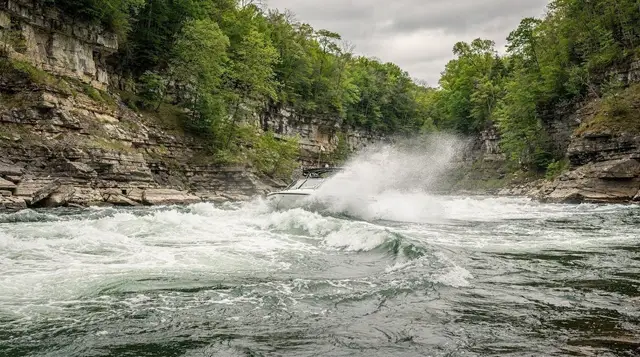
About four kilometres downstream from the falls, the river hits a hard left turn and the gorge widens into the Whirlpool: a natural basin roughly 518 by 365 metres and 38 metres deep, where the current spins in a slow, visible rotation before continuing north. The rapids feeding into it run about 1.6 kilometres and drop 15 metres, reaching speeds around 9 metres per second — this is not a stretch anyone swims or wades into, and the river here has drowned people who tried.
The classic way to see the Whirlpool without hiking is the Whirlpool Aero Car, a cable car that has run since 1916. Jet boats also run up into these rapids from the American side, which the jet boat tours guide covers in more detail than fits here.
a 45-minute jet boat run into the Niagara River’s rapids from the American sideThis entire gorge-and-Whirlpool stretch is what most people mean when they picture “the Niagara River” as a destination in its own right. It is compact — you could reasonably see the Aero Car, walk a section of the Glen, and be done in half a day. It is also the wrong stretch to expect wine, orchards, or a relaxed drive. That part of the river comes next.
Queenston: where the river goes quiet
North of the Whirlpool, the gorge walls drop away and the Niagara River changes character completely. Past Queenston, the escarpment flattens out, the current slows, and the river becomes navigable and calm for the rest of its run to Lake Ontario. This is the hinge point of the whole system: everything upstream of Queenston is gorge, rapids and hiking; everything downstream is flat water, farmland and wine country. Conflating the two is the single easiest mistake to make when planning a river-focused day — a visitor expecting more rapids scenery past Queenston will be disappointed, and one expecting vineyard views inside the gorge will be looking in the wrong place.
Queenston Heights, on the bluff above the village, is worth the stop on its own merits: a War of 1812 battlefield with a 56-metre monument to General Isaac Brock, who died here on 13 October 1812. The Queenston Heights and the War of 1812 guide covers the battle in more depth, and it pairs naturally with Fort George a few minutes north, and with Old Fort Niagara across the water in New York — the combined fort guide is useful if the War of 1812 is the thread you want to follow rather than the river itself.
The Parkway stretch: orchards, wineries and a long calm run
From Queenston to Lake Ontario, the Niagara Parkway traces the river’s bank for roughly 55 kilometres, and this is the stretch that has almost nothing to do with the falls. The land here is flat, the soil is good, and the whole area is planted with orchards and, increasingly, vineyards — the microclimate created by the escarpment and the lake moderates winter cold enough to grow riesling, chardonnay, pinot noir and the vidal grapes used for ice wine.
This is the Niagara wine region, and it deserves its own dedicated trip rather than a stop bolted onto a falls itinerary. The wine route guide lays out the appellation properly; if you only read one page about this stretch, that should be it.
Niagara-on-the-Lake sits where the river meets the lake, about 26 kilometres from the falls by the Parkway — roughly 25 minutes’ drive when traffic is light. It is a genuinely different kind of visit: a preserved 19th-century town with the Shaw Festival theatre, rather than an attraction built around a natural feature. Given that nobody should drive after a day of tastings, a driver or an organized tour is the practical way to see several wineries in one outing.
a private wine tour from Toronto that takes in Niagara-on-the-Lake and the surrounding vineyards a full-day wine and falls combination with tastings around Niagara-on-the-LakeCyclists have their own way to cover this stretch: the Niagara River Recreation Trail runs the length of the Parkway from Fort Erie to the lake, and the cycling the Parkway guide is the reference for doing it by bike rather than by car. For a quieter way to be on the water itself before the current picks up again downstream, paddling near Niagara-on-the-Lake is an option worth knowing about.
a guided kayaking outing on the river near Niagara-on-the-LakeWest of the Parkway, the river’s watershed also feeds the Welland Canal at St. Catharines — a separate 43.4-kilometre channel with eight locks that lets ships bypass the falls entirely between Lake Ontario and Lake Erie. It is not the Niagara River itself, but it exists because of the same drop the river cannot be navigated across, and the viewing platform at Lock 3 is a genuinely good stop if locks and shipping interest you; the Welland Canal guide has the schedule details. Port Dalhousie, where the old canal met the lake, has a beach and an antique carousel dating to 1905.
The mouth: two forts facing each other across the water
The river finally reaches Lake Ontario between Fort George on the Canadian side and Old Fort Niagara on the American side — two fortifications built to control the same river mouth from opposite banks, which tells you most of what you need to know about how contested this waterway once was. Old Fort Niagara’s French Castle dates to 1726, making it older than either country currently governing the shoreline around it. Neither fort requires a boat to visit; both sit at the natural end point of a river-focused itinerary that started at the gorge.
Deciding how much of the river to actually cover
The mistake worth naming directly: the Niagara River is not one outing. The gorge and Whirlpool stretch is compact, dramatic and can be done alongside a falls visit in half a day. The Queenston-to-lake stretch is calm, agricultural and needs its own half-day or full day, ideally with a driver if wine is involved. Trying to do both in one afternoon usually means rushing the gorge trails and skipping the wineries entirely, or the reverse. If you only have one extra day beyond the falls themselves, pick a side of the hinge at Queenston rather than trying to touch both.
| Stretch | What it is | Time needed | Getting there |
|---|---|---|---|
| Fort Erie to the falls | Quiet upstream current, mostly residential | Not a destination in itself | Drive-through only |
| Gorge and Whirlpool | Rapids, hiking trails, Aero Car, jet boats | 2 to 4 hours | 5 to 15 minutes from the falls |
| Queenston | Hinge point, War of 1812 sites | 1 to 2 hours | 10 to 15 minutes from the falls |
| Parkway to the lake | Wineries, orchards, Niagara-on-the-Lake | Half a day to a full day | 20 to 30 minutes from the falls |
| The mouth | Fort George and Old Fort Niagara | 1 to 2 hours each | 25 to 40 minutes from the falls |
For a longer trip that strings several of these stretches together properly rather than rushing them, the both sides in 48 hours itinerary and the wine and food itinerary are built around exactly this kind of pacing. And if you are still deciding how many days the whole region deserves, the how many days guide and the Canada vs. USA side comparison are the place to work that out before you commit to a route.
Questions about the Niagara River
Is the Niagara River the same thing as the falls?
No. The falls are one point along the river, roughly four kilometres from where the gorge begins. The river itself runs 58 kilometres from Lake Erie to Lake Ontario, and most of that length has nothing to do with the drop that creates the falls.
Can you swim in the Niagara River?
Not in the gorge or Whirlpool sections — the current there reaches speeds around 9 metres per second and has killed experienced swimmers. Some calmer spots near Fort Erie and Niagara-on-the-Lake are used for paddling and controlled water activities, but wading into fast-moving sections of the river anywhere near the gorge is genuinely dangerous, not just against the rules.
How long is the Niagara Gorge, and can you hike all of it?
The gorge is about 11 kilometres long. Trails exist on both banks — Niagara Glen on the Canadian side, the Niagara Gorge Trail system and Whirlpool State Park on the American side — but they are separate trail networks on separate sides of an international river, not one continuous path, and crossing between them means using a bridge, not the gorge floor.
What is the Whirlpool, and how do you see it?
The Whirlpool is a natural basin about 518 by 365 metres and 38 metres deep, where the river makes a sharp turn and the current visibly rotates before continuing downstream. The Whirlpool Aero Car, a cable car in operation since 1916, crosses directly above it; hiking trails on both banks also reach viewpoints, and jet boats run into the rapids feeding it from the American side.
Is the wine country actually on the river?
Yes, though it is well downstream of anything falls-related. Niagara-on-the-Lake and the wineries around it sit near where the Niagara River meets Lake Ontario, about 26 kilometres from the falls along the Parkway — a different landscape entirely from the gorge, flat and agricultural rather than dramatic.
Do you need a car to see the river properly?
For the gorge stretch, no — trails and the Aero Car are reachable on foot or by WEGO from the falls area. For the Parkway stretch toward Niagara-on-the-Lake and the wine region, a car, bike, or organized tour with a driver is the practical choice, particularly if tastings are involved, since nobody should drive after wine tasting.
Where does the Niagara River actually end?
At Lake Ontario, between Fort George on the Canadian bank and Old Fort Niagara on the American bank. Both forts were built specifically to control that river mouth, and visiting either one is a natural endpoint for a trip that follows the river’s course from the gorge northward.
Is one day enough to see the whole river?
Only if you accept seeing one stretch properly rather than all of them briefly. The gorge and Whirlpool can be covered in half a day; the Parkway and wine country need their own half-day at minimum. Combining both into a single rushed day usually means shortchanging the hiking or the wineries, not genuinely covering both.